
Diversity: Fire Succession in Arid Australia The importance of spatial scale has been neglected in traditional ecology, although not in the emerging field of landscape ecology. While the implications of the landscape on ecology have long been appreciated, only recently have quantitative methods of study been exploited. In the past, ecologists, including myself, have focused on local-level processes. Larger scale regional factors also control local phenomena. Local species richness may often be a consequence of regional processes. Relatively little empirical attention has been given to the interaction between these two levels. Unfortunately, few complete closed regions remain unfragmented by human activities in which regional and local phenomena can still be studied simultaneously. I have undertaken such a study in the uninhabited Great Victoria desert of Western Australia, an area with an extremely high diversity of lizards. 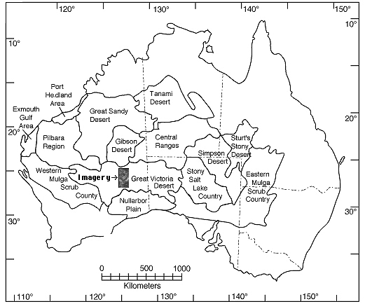 Fires were once a major agent of disturbance in all grassland and semidesert biomes, including the North American tall grass prairies. Most of these ecosystems have now been reduced to mere vestiges, and controlled burning and/or fire control are practiced by humans almost everywhere. The inland Australian desert is one of the last remaining areas where natural wildfires remain a regular and dominant feature of an extensive natural landscape largely undisturbed by humans. In this region, an important fire succession cycle generates spatial and temporal heterogeneity in microhabitats and habitats. Habitat-specialized species can go extinct within a given habitat patch (fire scar), but remain in the overall system by periodic reinvasions from adjacent or nearby patches of suitable habitat of different age. These regional processes facilitate local diversity. This system is currently being studied at the local level in the field in Western Australia and at the regional level at the University of Texas at Austin using aerial photography and multispectral satellite imagery. Macrographs, high resolution satellite images, offer a powerful new way, heretofore underutilized by biologists, to acquire regional level data on the frequency and phenomenology of wild fires, and thus the system-wide spatial-temporal pattern of disturbance. Several different approaches to modelling fire succession are being examined. |
|
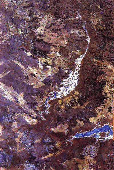
Much of the digital satellite data has been acquired by Landsat, archived on magnetic tape. A complete analysis of wild fires for the Great Victoria desert region requires about one hundred images. Imagery has been purchased and analyzed to detect burned areas. Spectral and spatial statistics have been computed for nearly a thousand fires, and the probability that a given area will burn has been estimated. Other data collated for each fire include: date, location, area, perimeter, compass direction (of burn and prevailing wind), ground cover characteristics, extent of reticulation, as well as various fractal dimensions. (To read more about the remote sensing study, click here) Age and size distributions of burn patches have been estimated. Eventually, I hope to acquire supporting imagery from other grassland areas, particularly the Kalahari semidesert of southern Africa, to use for comparative purposes (fires in the Kalahari do not appear to reticulate to as great an extent as they do in Western Australia). |

|
A major goal of this study is to obtain baseline data on temporal patterns, spatial structure, and distribution of disturbances. These data will form the backdrop for a more detailed study of the population dynamics and dispersal abilities of species. Animals with active habitat selection such as Australian desert lizards should reach ecological and evolutionarily stable equilibria between "source" and "sink" habitats, with dispersal from the former to the latter maintaining the species locally. Such data on the metapopulations of component species will eventually be fitted into the overall spatial-temporal mosaic in an effort to explain the persistence of this diverse desert fauna. Ultimately, I plan to model the entire Great Victoria desert region as a dynamic habitat mosaic so as to understand mechanisms of coexistence of its component species and the effects of fire disturbance in maintaining diversity in this region. Faunas of unstudied sites will be predicted by extrapolation, thus allowing models to be to subjected to direct test. It should also be feasible to exploit controlled burns to test some aspects of such fire succession models. To read about this project in greater detail, use this link. 
References Haydon, D. T. and E. R. Pianka. 1999. Metapopulation theory, landscape models, and species diversity. EcoScience 6: 316-328. Download pdf. Haydon, D. T., J. K. Friar, and E. R. Pianka. 2000. Fire Driven Dynamic Habitat Mosaics in the Great Victoria Desert I: Fire Geometry. Landscape Ecology 15: 373-381. Abstract, Download pdf. Haydon, D. T., J. K. Friar, and E. R. Pianka. 2000. Fire Driven Dynamic Habitat Mosaics in the Great Victoria Desert II: A spatial and temporal landscape model. Landscape Ecology 15: 407-423. Abstract. Download pdf. Pianka, E. R. 1992. Fire Ecology. Disturbance, spatial heterogeneity, and biotic diversity: fire succession in arid Australia. Research and Exploration 8: 352-371. Download pdf. Pianka, E. R. 1994. Biodiversity of Australian desert lizards. In C. I. Peng and C. H. Chou (eds.) Biodiversity and Terrestrial Ecosystems. Institute of Botany, Academica Sinica, Monograph Series No. 14, pp. 259-281. Download pdf. Pianka, E. R. 1996. Long-term changes in Lizard Assemblages in the Great Victoria Desert: Dynamic Habitat Mosaics in Response to Wildfires. Chapter 8 (pp. 191-215) in M. L. Cody and J. A. Smallwood (eds.) Long-term studies of vertebrate communities. Academic Press. Download pdf. Pianka, E. R. and S. E. Goodyear. 2012. Lizard responses to wildfire in arid interior Australia: Long-term experimental data and commonalities with other studies. Austral Ecology 37: 1-11. Download pdf. Return to Pianka lab page |